*AKA what I’ve dubbed “The Wikipedia Three” – as of June 2023, each mountain’s Wikipedia page has a “See also” section that refers to the other two but to no others, for no particular reason that I can see.
No-one writes about how airy the scrambling is on Suilven’s middle peak. It hasn’t even got a name! And no-one tells you that striking due north from the lower slopes of the far-end peak, Meall Beag, to try and reach the footbridge at the western end of Loch na Gainimh isn’t a good idea. Most of all, seemingly no-one has told the tale of how tough trying to combine all that with an ascent of Canisp from the west on the same day is. And so begins what is in many ways a cautionary tale…
It all started well enough. After an achingly long drive up from West Yorkshire, I ditched the car near Glencanisp Lodge (see other blogs for a description)…

…donned my rucksack full of overnight gear and the stuff I’d need the next day (in a bag inside that bag) during one of those endless sunsets the NW Highlands experience in mid-June…

…and trudged the three miles to Suileag bothy…
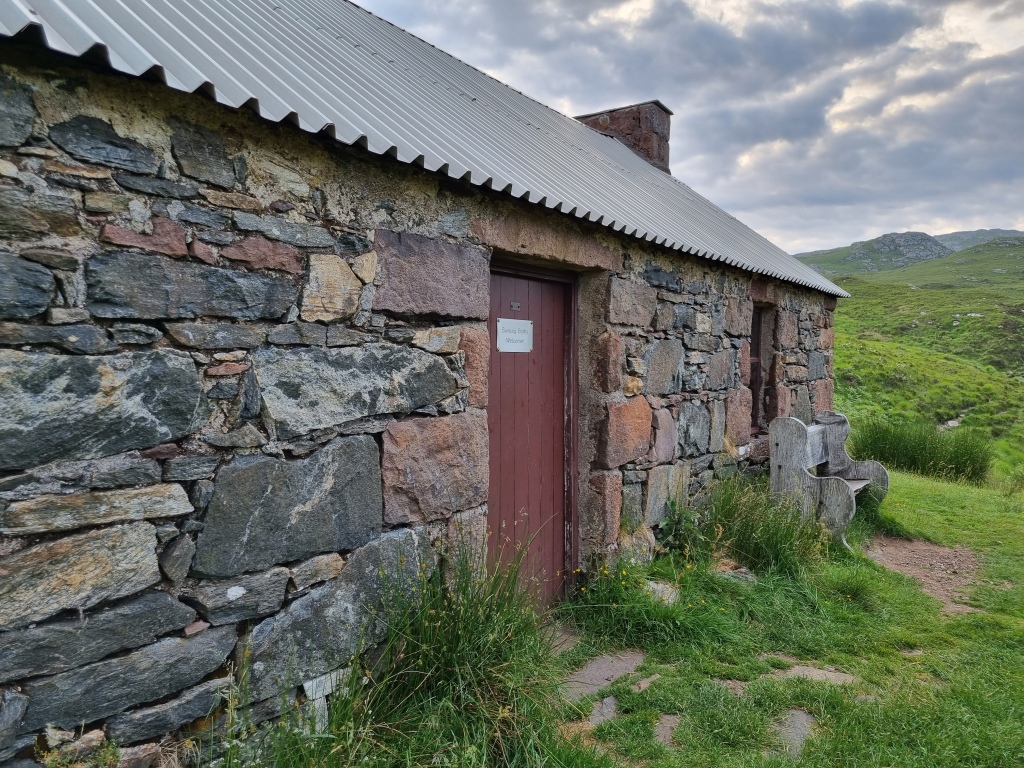
…tucked away behind a hillside dry stone wall enclosure. It’s a sparse but surprisingly Tardis-like place…

…with what looked like recently-installed bunk platforms in the main dorm…

…that I feel sure could sleep 20 were the upstairs (inaccessible when I was there) employed, but I only had the one fellow “bothy-er” that night (hello, Freddie from Edinburgh, if you’re reading this!).
Dawn brought rapidly clearing skies…

…so without much ado I was off. Just over an hour took me along a further length of stalker’s path…

…off to the right up the recently-improved approach path proper…

…(still, at the time of writing, unmarked on the Explorer map of the area – sort that out pronto, Ordnance Survey! – but essentially the junction is equidistant between the footbridge I’ve already mentioned and an earlier one)…

…and past Loch a’ Choire Dhuibe to the foot of the well-trodden stone chute…

…that leads to the lowest point of the ridge, the Bealach Mòr. Now, recently-repaired or not, that is some undertaking! I count myself as a reasonably fit, experienced fortysomething walker, with an admitted tendency to bound up hills at a rate that does neither my heartrate nor my breathing any good whatsover, but by God! The approach track was bad enough to slow me right down in places, but well before the halfway point of said chute it was a case of stagger twenty steps, stop to allow the aforementioned vital functions to return to something approaching normal, then repeat until it was all over. It took around 40 minutes in total…at which point the cloud rolled in…
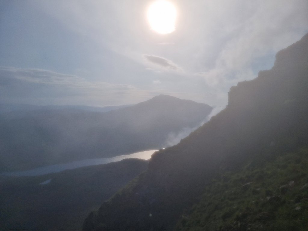
…and for a few borderline-tearful minutes it looked like the fabled view south to Cùl Mòr and Stac Pollaidh might never appear after all that will-to-live-sapping effort. But then the cloud not only started to lift off…
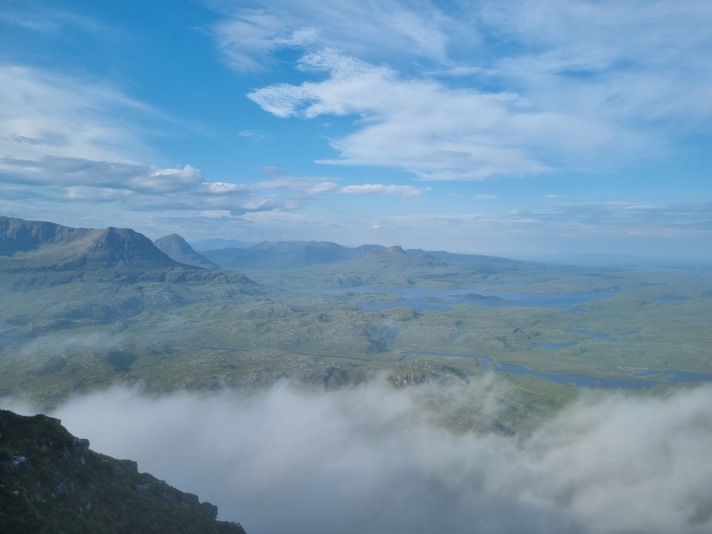
…it stayed lifted-off for the rest of the day. After a few pics, I quickly turned right and headed for the gap in the man-made wall that everyone comments on (so I won’t bother – again, please see other blogs)…

….passing four overnight wild-campers on the way (two on their way down from the westernmost and highest peak on the ridge, Caisteal Liath; two who’d camped further down and were valiantly attempting to fold their tent in a stiffening easterly breeze). The way involved a fair bit of steep up-and-down, but nothing like what I’d already encountered, and the exposure wasn’t too silly at this point…
…(on the way back down, I even dared myself to step wobblingly across to an isolated pinnacle, with absolutely vertical straight-down on all sides, like I’d seen the author of this video do, as a resolve-stiffening exercise). And as for the views from the summit cairn…well, see for yourself…
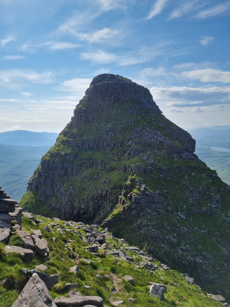
Once back at the bealach, it was time to steel myself for the rest of the ridge. To start with, The Peak with No Name…

I’m not the most battle-hardened scrambler in the world, and so I really had done my online/hard-copy homework (obsessively repeated it, in fact) on what to expect, suggested lines to take, etc., along with a bit of cheeky practice on some exposed millstone grit rockfaces in a mercifully-always-quiet park near my office. However, as I’ve already indicated, writers tend to skirt over its difficulties, and I’m not really sure why, because this seemed far scarier than the bits one is warned about, perhaps because I wasn’t forearmed; maybe because, unlike with the later-on scrambling, here you’re frequently turning this way and that while pressed right up against the mountain’s sheer flanks, vividly aware that (again, unlike the more “hemmed-in” scrambling that’s to come) there’d be zero chance of self-arrest were you to start to tumble; but most likely a combination of the two. There’s also a lot of it for an anonymous hill…

Anyway, finally it was over, and a few awkward downhill steps (I haven’t mentioned that by this point – I blame the chute! – I’d already started to feel the first twinges of what proved to be borderline-crippling cramp in my quads, somewhere I’d never experienced cramp before)…
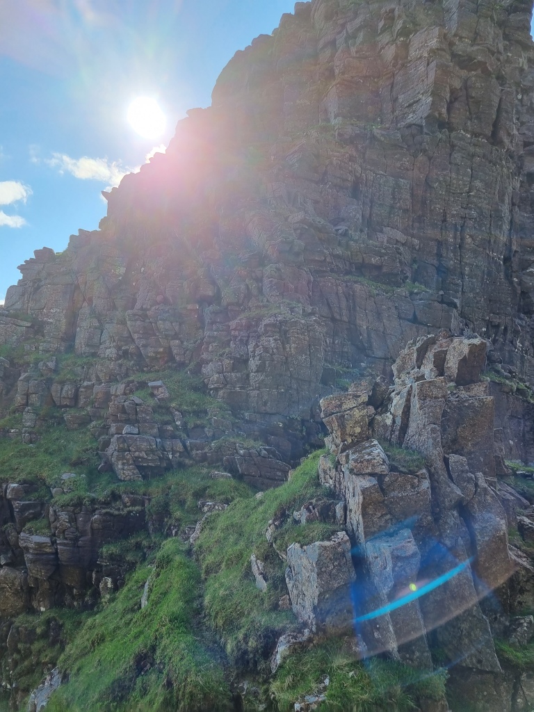
…brought me to the narrow (but not too frighteningly so) notch below Meall Meadhonach, Suilven’s second-highest point. The path up this, which skirts some high-grade but entirely optional bouldering, was steep but manageable after what had gone before, although occasionally tricky to pick out “close up”. Near the summit, the scrambling suddenly becomes non-optional, and grade 2 or 3 depending on which source you believe (personally, I side with the Scottish Mountaineering Club’s 2 rating): on encountering a long, detached boulder, you begin to pick your way up a series of steps, veering slightly to your left, until you reach a narrow, grassy ledge on which perches what other writers have described variously as a jumble of rocks and a hollow tower. This is easy to spot even from a distance, and also sturdier than it looks, being fairly straightforward to climb on the left hand side. From the top, you need to latch on to a horizontal crack with both hands, so that you can do a fair-sized “splits” to your right to get a foothold on a ledge. The cliff face directly facing you at this point is comparatively low, and some kind soul when I did this walk (June 2023) had left a short length of climbing rope and carabiner securely fastened at left-hand height (please, no one move them!). Using either this kit or the more traditional hand-on-rock, it’s just a short haul upwards to find yourself almost anticlimactically presented with a rocky but gentle amble to the summit. Feel free to let out out an echoey whoop of triumph/relief at this point – I did!
From the cairn of MM (which is what all the cool kids are calling it these days), I followed the teardrop-shaped summit plateau until it narrowed and started to descend; from here, the crown of Meall Beag, the ridge’s final, diminutive challenge, began to emerge…

A short downclimb over the left-hand side of the teardrop’s “point” unveiled a steeply sloping patch of grass and rock (this photo looks back at it, so it’s on the right here)…

….on which one is supposed to follow a zigzagging path…

…but I found the latter to be difficult to follow and constantly disappearing, so was making it up more often than not, and by this time the cramp in my quads was really starting to bite, causing me at one point to yelp the expletive that rhymes with “duck” at maximum volume. This, coupled with a second whoop on summiting MB (come on, you know it’s a thing now!), appeared to summon Mountain Rescue; certainly, one of their helicopters appeared overhead a short while afterwards. I gave them my cheeriest and most “I’m not in difficulty, honest” wave, which the crew appeared to interpret correctly, as they carried on up Glencanisp without so much as the proverbial backward glance.
Anyway, back to MB. The downward torture finally over, I found another narrow col whose much-discussed vertiginousness belies the steeply sloping, but far from straight-down reality, with a curiously “spiky” rock formation (around eight feet high, at a guess, for scale?) at its centre. The path passed this litho-asterisk on the left…
…then ascended a couple of grassy steps before unavoidably veering left round a jutting overhang. Again, the possibility of anyone sufficiently level-headed to have made it this far to be scared by this prospect has been exaggerated: all it requires is two well-planted hands and some thoughtful foot-placement. The path continues to wind upwards in a succession of rocky steps and terraces, each getting seemingly further from the void little by little, until around the halfway point, at which point it switches abruptly round to the right, with a goodly stretch of grassy slope beneath you. All that now stands between the enterprising scrambler and the top is a sloping slab and some more stony steps.
I couldn’t quite relax on reaching the summit cairn (absolutely weeny – maybe four or five small stones used), however, as I knew from my research that there was one more very tricky bit to go – a deep trench cutting across the entire summit from left to right, the crossing of which requires either a big run-up-and-jump or a somewhat inelegant climb down to a narrow causeway (I chose the second option). That negotiated, I made my way cautiously down the comparatively-gentle-but-stony incline on the far side, continuing to walk with the rest of the mountain behind me…

…until turning sharp left and making my big northbound mistake. Don’t do it! Sure, it’s theoretically more direct for the aspiring Canisp-climber than the SMC’s recommendation to make for a footbridge to the east of the loch, but if you do as I did you’ll face a seemingly interminable slog over foot-catching heather and rock, culminating in a self-esteem-draining bum-shuffle down to the water’s edge whose gradient gives plenty of the summit ridge a run for its money: precious little (if any) time saved, and far more energy expended.
As a result, my depiction of what followed will be somewhat blurry, as it was largely conducted in a haze of resentful (so arguably ungrateful – I was the one who’d insisted on taking a long weekend away from the wife and kids to do this, after all!) exhaustion during what by now had become a mercilessly sun-baked day. I couldn’t even be bothered to take many photos from this point on, knowing by now that any slowing-down or stopping would result in a fresh assault from an army of cleg flies, ticks (thankfully either Lyme-free or dealt with swiftly enough for the disease not to transmit – I didn’t want to add those symptoms to my already-lengthy-enough-thank-you list of ailments), etc. that had somehow sussed I was the only mammal in the vicinity. But essentially, after flopping down on the eventually-located footbridge for a few peaceful minutes…

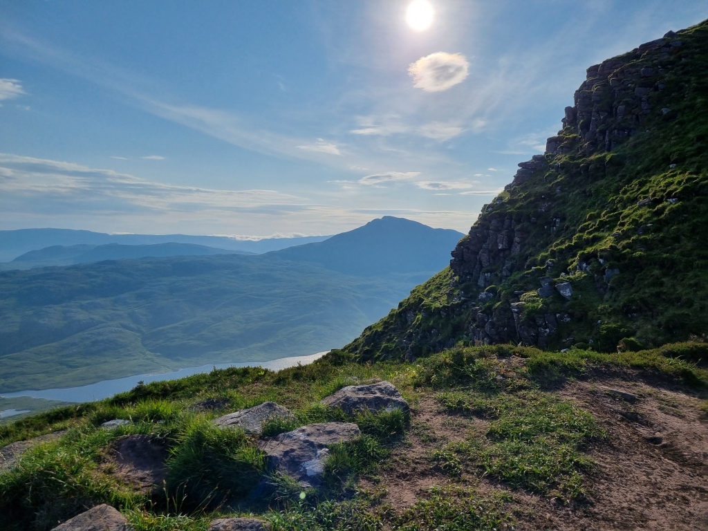
….I continued further along the stalker’s path I’d left nearly five hours earlier on my approach to Suilven, forking left after a few hundred yards to join another, vehicle-tracked such path that winds its way up between cnocs (the big, knobbly outcrops of gneiss for which Assynt is famed) to reach a flattish wilderness (above which Canisp stretches upwards at around two o’clock to the walker)…and then, according to the map (again, OS…?!) promptly vanishes in the middle of nowhere. Thankfully, I’d already established via a walking app that what actually happens is it continues snaking as a single track, only occasionally disappearing in bog, up to an unnamed lochan sitting directly below the Corbett’s west ridge, with around three-fifths of the ascent from Loch na Gainimh already completed; this shot, taken “in happier times” from Meall Beag, gives a fair impression of the topography to expect…

The ridge itself is a succession of increasingly rocky bumps (I’d now resorted to treating the gaining of each as a massive victory in itself), the rock abruptly changing from the sandstone that predominates on the area’s mountainsides to strikingly grey-white quartzite about fifty metres from the summit. Don’t bother looking for a clear path running the length of the ridge: there isn’t one; what there is are a succession of short stretches of path that either peter out or head off unexpectedly in the wrong direction, so my advice is to be grateful to have them as your companions for as long as they’re useful to you, but be prepared to be a fair-weather friend and abandon them at any moment in order to stay on course. From the footbridge, I’d estimated reaching the top by 1pm; by the time I’d stop-and-started my way up and along to the circular summit shelter (no cairn here), it was nearer 2.15. I took my last three mountain photos of the day, one the obligatory summit selfie where “ordeal” is etched into every feature of my face (which I’ll spare you) and the others respectively a “normal”…

…and zoomed-in shot looking back across at Suilven; discovered I had 4G so made some brief communications letting family know I was still alive, ate and drank copiously; then prepared to make a pained but “no stopping on anyone/anything’s account” route-march all the way back to the bothy, where I’d stowed my overnight stuff and already resolved to catch forty winks before making the final push for the car. Several lifetimes later, I shambled into the dorm, discovered what turned out to be the two tent-wranglers from the morning already asleep on two of the bunks, gulped down most of my remaining water, crawled onto my still-inflated mattresses, and essentially passed out for the best part of an hour.
My stamina somewhat restored, another eternal evening beckoned as I set off for the final leg, arriving back at the car park almost exactly 24 hours after I’d left it. A twisty, hilly 15-minute drive, largely on single-track roads, brought me to Achmelvich Bay, with its sand so white it looks fake…

….and the youth hostel thereat. After spending sometime acquainting myself with the place and its inmates, and getting myself clean, changed and well enough fed/rehydrated to feel almost human again, I retraced my drive back as far as Lochinver with the intention of having a single, celebratory alcoholic drink. My experience there was brief and unwelcoming; I’ll name no names, but it involved bloody-mindedly downing a pint of lager (ugh! I’d earned something, but ugh!) at top speed before fleeing back to Achmelvich. No matter: I had one more mission before bed – to locate Hermit’s Castle.
“What’s Hermit’s Castle?” Well, I’ll once again leave my readers to Google the answer, but for those in the know about its existence/nature, here’s how I found it; other, probably more direct approaches, are available: after crossing the car park from the youth hostel end and following the road until it bends sharply left, walk on the grass to the far end of a row of statics and cottages, keeping the fence on your left and the path to the beach on your right. Go left over a stile and then right through a gate, then walk directly over the top of the first rocky outcrop and down into a kind of valley between two further outcrops (full of cotton-grass at the time). Follow this valley virtually to the water’s edge, then turn c.90 degrees to your left, et voilà – you get a side-view of the castle with the doorway to the right, and a short rocky stretch of shoreline betwixt you and it…

And what a fantastically weird wee place it is…!

The aforementioned door reaches right up to roof-height, and even then a man of average height such as yours truly needs to stoop slightly to get through the tiny porch area and into the main chamber. There’s a bench and a few shelves in one corner…

….and a stone platform for sleeping on…

That’s it; there isn’t room for anything else. I’m sure our little geodesic three-man has more living space!
You do meet “characters” in hostels, don’t you? One such, with whom I was sharing a (unisex, but discreetly curtained-off) dorm, had greeted my stated plan to climb Stac Pollaidh the next day with a superior smile and “Have you seen the forecast?!” No – I hadn’t exactly been in up-to-date-online-forecast country, and by that evening most of the UK had been experiencing suffocatingly warm dryness for weeks: why wouldn’t that continue? And when, the following morning, I awoke to steady rain and managed to cajole the local 4G into giving me sufficient signal, the Met Office app was still suggesting that these conditions would ease mid-morning, giving me a sufficient window to get up and down before closing in again. So I went for it: gathering up my gear and negotiating yet more oh-so-Sutherland single-track roads (clogged with cows, which didn’t even have the decency to be proper Highland coos, at one point), I found myself staring up at the cloud-wreathed summit ridge from the car park and hoping. I stiffly set off up the path and out into the great grassy expanse that sits below said ridge, still hoping…

I forewent the track up to the ridge and continued along the path that loops round it, and still I hoped. The path starting to descend to the car park again, I looked up one final time. You bastard! The cloud had finally lifted, just too late for me…

Oh well, I reasoned, it was blowing a gale and the rain was now coming down with a vengeance, which would have made conditions tricky anyway on a ridge that is notorious for claiming lives; did I really want to risk adding to that statistic when there was always the chance of a “next time”? Thus consoled, I concluded my visit to Coigach by doing the only thing a rational human being facing the double-whammy of a disappointment like that and the prospect of another epic drive, this time homeward, would do: making my way to Ullapool and consuming the most protein-dominated, artery-clogging fry-up the world has ever seen…
